Nepal-China Border Flash Flood Explained: How a Glacial Collapse Triggered a Catastrophic Disaster
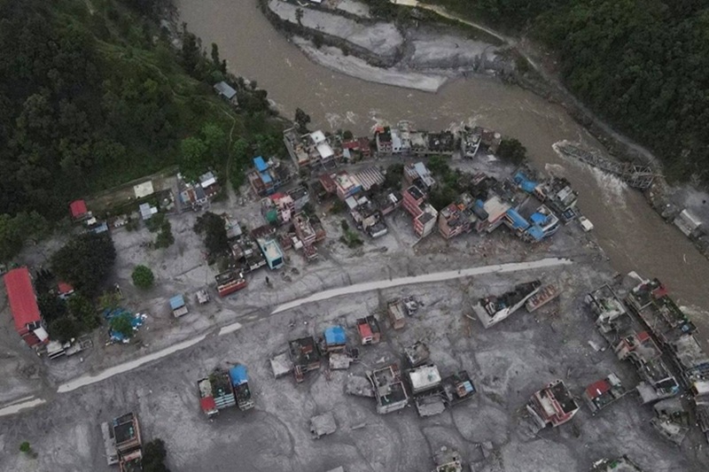
On August 26, 2026, something broke loose high in the Himalayas near the Langtang region, close to where Nepal meets China. At an altitude above 5,000 meters, a chunk of glacier and the mountainside beneath it gave way all at once. What followed wasn’t a slow, rising flood; it was an avalanche of ice and rock that slammed into the Lhende river system and turned, almost instantly, into a wall of mud, water and debris tearing down the valley. By the time it was over, the surge had traveled nearly 100 kilometers, ripping through the Lhende Khola, Bhote Koshi and Trishuli river corridors. As of September 1, Nepal’s death toll stood at 987, with more than 4,000 people still unaccounted for numbers that make this one of the country’s worst natural disasters in recent memory.
A Disaster That Built on Itself
It’s tempting to call this a flash flood and leave it there, but that undersells what actually happened. This was a cascade: a glacier collapse set off an avalanche, the avalanche crashed into the river, and that collision generated the flood. Each stage fed the next, and it all happened fast enough that there was little time for warning. Speed was really the defining feature of the disaster. Steep terrain gave the falling ice and rock enormous momentum before it ever reached the water, and that force carried straight through into the flood wave. The border crossing at Rasuwagadhi, a key trade link between Nepal and China was hit hard, as were the Gyirong facilities on the Chinese side. Entire villages downstream were buried or simply washed away. Roads and bridges vanished under debris. Hydropower plants, a cornerstone of Nepal’s energy ambitions, took heavy damage too, and rescue crews have been racing to reach workers trapped in tunnels and remote project sites ever since.
Was Climate Change to Blame?
Scientists are being careful here, and for good reason pinning a single event on climate change is never straightforward. But the broader trend is hard to ignore: rising temperatures are destabilizing glaciers and mountain slopes across the Himalayas, speeding up melt and shifting rainfall patterns in ways that make slopes less stable. Reports pointed to an unusual warm spell in the days before the collapse, though researchers stop short of drawing a direct line between that and the disaster itself. There’s one interesting wrinkle: satellite data from the NASA-ISRO NISAR mission picked up ground deformation in the area where the collapse occurred. It’s not something that predicted the event that was noticed only afterward but it’s the kind of signal scientists hope to use for earlier warnings down the road.
The Ongoing Rescue
More than 11,000 people have been pulled to safety so far, many by helicopter, since so many roads, bridges, power lines and communication networks were destroyed. The work isn’t over; authorities are keeping a close eye on newly formed lakes and loose debris upstream, worried that a collapse of those natural barriers could unleash another round of flooding.
Stay informed with the latest stories making headlines worldwide.
Could Typhoon Narra Worsen China Floods?
Check out how Typhoon Narra is affecting southern China and displacing thousands.
Can Pakistan-Iran Talks Bring Peace?
Find out how Pakistan-Iran talks are progressing toward regional peace and stability.
Why Is Saudi Arabia Investing Near Paris?
Uncover Saudi Arabia’s $7 billion plan to build three theme parks near Paris.
How Did Death Valley Turn Deadly?
See what happened when a French tourist became stranded in extreme Death Valley heat.
Will Pakistan-Iran Talks End Conflict?
Track down the latest developments as both sides push to resolve the regional conflict.
Why It Matters Far Beyond the Mountains
What happened near Rasuwagadhi is a stark reminder of how fast a hazard forming high in the mountains can turn into a crisis for communities, economies and infrastructure hundreds of kilometers away. It disrupted trade between two countries, devastated a hydropower sector Nepal has been counting on for growth, and left a trade route in ruins. It’s also a case study in why disasters like this can’t really be handled by one country alone, cross-border monitoring and cooperation matter when a river system doesn’t respect a national boundary.
Above all, it’s a warning that in a warming Himalayan environment, glacial hazards can now move faster than the systems built to warn people about them.
FAQs
1. What caused the Nepal-China border flash flood?
A large collapse involving glacier ice and underlying rock triggered an avalanche and powerful debris flow that entered the Himalayan river system.
2. When did the Nepal-China border flood happen?
The disaster began on August 26, 2026, in the Himalayan border region between Nepal and China.
3. Was the flood caused by an earthquake?
An earthquake-like seismic signal was initially reported, but the U.S. Geological Survey later said the signal was generated by the landslide itself rather than a separate earthquake.
4. How serious is the disaster?
As of September 1, Nepal had reported at least 987 deaths and more than 4,000 people missing, with rescue operations still underway. China also reported deaths and hundreds missing.
5. Could similar Himalayan floods happen again?
Yes. Glacial instability, landslides, extreme rainfall and rapidly changing mountain conditions mean Himalayan communities remain exposed to cascading flood hazards. Improved monitoring and early-warning systems can help reduce future losses.